


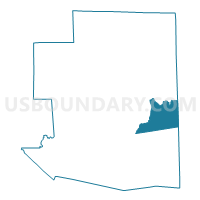
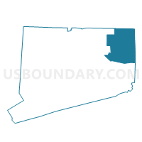
Killingly 3-44 Voting District, Windham County, Connecticut
About
Outline

Summary
| Unique Area Identifier | 550186 |
| Name | Killingly 3-44 Voting District |
| County | Windham County |
| State | Connecticut |
| Area (square miles) | 19.64 |
| Land Area (square miles) | 19.13 |
| Water Area (square miles) | 0.50 |
| % of Land Area | 97.43 |
| % of Water Area | 2.57 |
| Latitude of the Internal Point | 41.79763200 |
| Longtitude of the Internal Point | -71.83705500 |
Maps

Graphs
Select a template below for downloading or customizing gragh for Killingly 3-44 Voting District, Windham County, Connecticut


Neighbors
Neighoring Voting District (by Name) Neighboring Voting District on the Map
- Brooklyn 1 Voting District, Windham County, CT
- Killingly 1-44 Voting District, Windham County, CT
- Killingly 2-44 Voting District, Windham County, CT
- Killingly 2-51 Voting District, Windham County, CT
- Killingly 4-44 Voting District, Windham County, CT
- Killingly 5-44 Voting District, Windham County, CT
- Plainfield 3 Voting District, Windham County, CT
- Plainfield 4 Voting District, Windham County, CT
- Sterling 1 Voting District, Windham County, CT
Top 10 Neighboring County Subdivision (by Population) Neighboring County Subdivision on the Map
- Killingly town, Windham County, CT (17,370)
- Plainfield town, Windham County, CT (15,405)
- Brooklyn town, Windham County, CT (8,210)
- Foster town, Providence County, RI (4,606)
- Sterling town, Windham County, CT (3,830)
Top 10 Neighboring Place (by Population) Neighboring Place on the Map
Top 10 Neighboring Elementary School District (by Population) Neighboring Elementary School District on the Map
- Brooklyn School District, CT (8,210)
- Foster Elementary School District, RI (4,606)
- Sterling School District, CT (3,830)
Top 10 Neighboring Secondary School District (by Population) Neighboring Secondary School District on the Map
Top 10 Neighboring Unified School District (by Population) Neighboring Unified School District on the Map
Top 10 Neighboring State Legislative District Lower Chamber (by Population) Neighboring State Legislative District Lower Chamber on the Map
- State House District 44, CT (25,176)
- State House District 51, CT (24,985)
- State House District 50, CT (24,033)
- State House District 40, RI (14,561)
Top 10 Neighboring State Legislative District Upper Chamber (by Population) Neighboring State Legislative District Upper Chamber on the Map
- State Senate District 29, CT (103,291)
- State Senate District 18, CT (102,472)
- State Senate District 24, RI (27,542)
Top 10 Neighboring 111th Congressional District (by Population) Neighboring 111th Congressional District on the Map
Top 10 Neighboring Census Tract (by Population) Neighboring Census Tract on the Map
- Census Tract 9051, Windham County, CT (8,210)
- Census Tract 9041, Windham County, CT (7,466)
- Census Tract 9045, Windham County, CT (5,819)
- Census Tract 9072, Windham County, CT (5,506)
- Census Tract 133, Providence County, RI (4,606)
- Census Tract 9071, Windham County, CT (4,413)
- Census Tract 9044, Windham County, CT (4,085)
- Census Tract 9081, Windham County, CT (3,830)
Top 10 Neighboring 5-Digit ZIP Code Tabulation Area (by Population) Neighboring 5-Digit ZIP Code Tabulation Area on the Map
- 06239, CT (11,183)
- 06234, CT (8,244)
- 06241, CT (6,650)
- 06354, CT (6,141)
- 02825, RI (5,377)
- 06377, CT (2,962)